|
Northeastern New Mexico and Colorado Heavy Snow –
Tuesday Night through Friday Night - Update #3…
Issued: 7:50 AM MST | Friday November 8, 2024
|
|
|
Purpose:
- To provide reported snowfall amounts and to address additional snowfall amounts for today through tonight in the impacted region of northeastern New Mexico and Colorado.
- To address the increase in event snowfall totals in the Denver and Colorado Springs Metros based on observed totals and forecast trends.
|
|
|
Winter Weather Overview:
Area At Risk for Impactful Winter Weather:
- Northeastern New Mexico & Colorado
Begins: Ongoing in central & southern Colorado (including Colorado Springs) and northeastern New Mexico and is beginning in northern Colorado (including Denver and Boulder) this morning.
Ends: Friday night
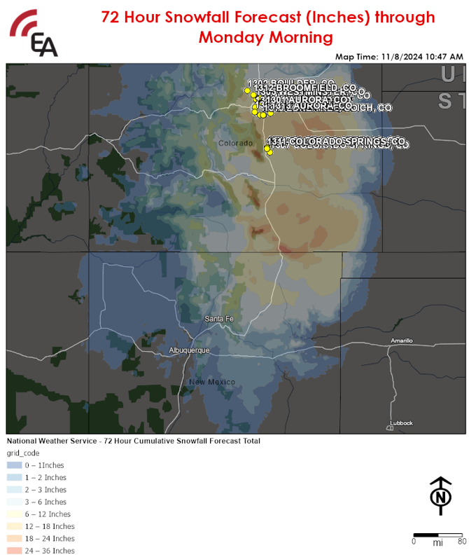
Reported Snowfall Amounts in Inches:
- Las Vegas, NM: 24"
- Raton, NM: 5"
- Santa Fe, NM: 12"
- Albuquerque, NM: 5"
- Monte Vista, CO: 14"
- Pueblo, CO: 4"
- Colorado Springs, CO: 12"
- Denver, CO: 5-10" (highest south of the city)
- Aurora, CO: 11"
- Boulder, CO: 9"
- Trinidad, CO: 23"
Threat(s): Heavy Snow
- An
additional 1-4 inches is expected along the I-25 corridor in northeastern
New Mexico including the greater Santa Fe Metro through this afternoon
with locally higher amounts of 5-8 inches across Las Vegas and Raton.
- An
additional 6-12 inches in the greater Denver & Colorado Springs Metros
northward through Boulder with locally higher amounts of 10-15 inches
possible in Trinidad.
Additional Details:
- In central
& southern Colorado, light to moderate snow is beginning this morning
and will become heavy at times this afternoon and continue through tonight
before mixing with and changing to rain.
- In northern
Colorado, snow is expected to resume later this morning, becoming heavy at
times beginning this afternoon. Snow will continue in these areas through
tonight before mixing with or changing to rain by Saturday morning.
- In
northeastern New Mexico, scattered snow showers are expected to continue across
the greater Santa Fe Metro this morning and afternoon before ending early this
evening.
|
|
|
Potential Disruptions & Recovery Weather:
- In central &
southern Colorado, light to moderate snow is ongoing this morning which
will become heavy at times throughout the day with the greatest impacts to
travel expected late this morning through late this evening.
- In northern Colorado,
snow will resume this morning with the greatest impacts to travel expected
this afternoon through tonight with conditions improving Saturday morning
as the precipitation changes to plain rain.
- Visibility may fall
below 1/2 mile at times with snowfall rates as high as 1-2 inches per
hour.
- In northeastern New
Mexico, wind gusts of up to 35 mph will combine with the heavy snow this
morning which will result in near-blizzard to blizzard conditions at times
through this afternoon.
- Where heavy snow results
in depths approaching and/or exceeding 20 inches, roof loading will become
an issue on uncleared flat roof buildings.
- Across the impacted
region, high temperatures into the mid-30s F to lower 40s F today and
Saturday will rise into the mid-40s to mid-50s F on Sunday and Monday
which will aid with the melting of accumulated snowfall on roadways.
- However,
melted snowfall may refreeze in the overnight to early morning hours each day
Saturday through Monday, resulting in patchy black ice formation on roads with
the worst travel conditions on secondary roads.
|
|
|
|
|
|
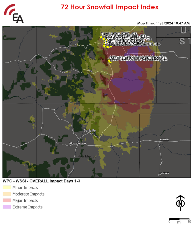
72 Hour Snowfall Impact Index:
|
|
| Name | Code | City | State | Zipcode |
| 1313 AURORA, CO | TMW | AURORA | CO | 80016 |
| Name | Code | City | State | Zipcode |
| 1307 COLORADO SPRINGS, CO | TMW | COLORADO SPRINGS | CO | 80922 |
| 1311 COLORADO SPRINGS, CO | TMW | COLORADO SPRINGS | CO | 80920-3206 |
| 457 COLORADO SPRINGS, CO | JBC | COLORADO SPRINGS | CO | 80920 |
| 1310 LONE TREE, CO | TMW | LONE TREE | CO | 80124 |
| 1304 HIGHLANDS RANCH, CO | TMW | HIGHLANDS RANCH | CO | 80126 |
| 44 ENGLEWOOD, CO | JBC | ENGLEWOOD | CO | 80112 |
| 1308 LITTLETON, CO | TMW | LITTLETON | CO | 80123 |
| 38 AURORA, CO | K&G | AURORA | CO | 80012 |
| 1306 LAKEWOOD, CO | TMW | LAKEWOOD | CO | 80226 |
| 1301 AURORA, CO | TMW | AURORA | CO | 80012 |
| 1096 Commerce City, CO | SSU | Commerce City | CO | 80022 |
| 1305 WESTMINSTER, CO | TMW | WESTMINSTER | CO | 80031 |
| 35 NORTHGLENN, CO | K&G | NORTHGLENN | CO | 80234 |
| 1312 BROOMFIELD, CO | TMW | BROOMFIELD | CO | 80021 |
| Name | Code | City | State | Zipcode |
| 1302 BOULDER, CO | TMW | BOULDER | CO | 80301 |
|
|
|
Updates:
- This will be the final update for this event barring an unexpected significant change in the forecast.
|