EA Special Hazard Report | Northeastern New Mexico & Colorado Heavy Snow – Tuesday Night through Friday Night - Update #3 - 7:50 AM MST | Friday, November 8, 2024...

clientlogo sfa background

Northeastern New Mexico and Colorado Heavy Snow –
Tuesday Night through Friday Night - Update #3…

Issued: 7:50 AM MST | Friday November 8, 2024

Purpose:

  • To provide reported snowfall amounts and to address additional snowfall amounts for today through tonight in the impacted region of northeastern New Mexico and Colorado.
  • To address the increase in event snowfall totals in the Denver and Colorado Springs Metros based on observed totals and forecast trends.

Winter Weather Overview:

Area At Risk for Impactful Winter Weather:

  • Northeastern New Mexico & Colorado

Begins: Ongoing in central & southern Colorado (including Colorado Springs) and northeastern New Mexico and is beginning in northern Colorado (including Denver and Boulder) this morning.

Ends: Friday night

Reported Snowfall Amounts in Inches:

  • Las Vegas, NM: 24"
  • Raton, NM: 5"
  • Santa Fe, NM: 12"
  • Albuquerque, NM: 5"
  • Monte Vista, CO: 14"
  • Pueblo, CO: 4"
  • Colorado Springs, CO: 12"
  • Denver, CO: 5-10" (highest south of the city)
  • Aurora, CO: 11"
  • Boulder, CO: 9"
  • Trinidad, CO: 23"

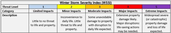
Threat(s): Heavy Snow

  • An additional 1-4 inches is expected along the I-25 corridor in northeastern New Mexico including the greater Santa Fe Metro through this afternoon with locally higher amounts of 5-8 inches across Las Vegas and Raton.
  • An additional 6-12 inches in the greater Denver & Colorado Springs Metros northward through Boulder with locally higher amounts of 10-15 inches possible in Trinidad.

Additional Details:

  • In central & southern Colorado, light to moderate snow is beginning this morning and will become heavy at times this afternoon and continue through tonight before mixing with and changing to rain.
  • In northern Colorado, snow is expected to resume later this morning, becoming heavy at times beginning this afternoon. Snow will continue in these areas through tonight before mixing with or changing to rain by Saturday morning.
  • In northeastern New Mexico, scattered snow showers are expected to continue across the greater Santa Fe Metro this morning and afternoon before ending early this evening. 

Potential Disruptions & Recovery Weather:

  • In central & southern Colorado, light to moderate snow is ongoing this morning which will become heavy at times throughout the day with the greatest impacts to travel expected late this morning through late this evening.
  • In northern Colorado, snow will resume this morning with the greatest impacts to travel expected this afternoon through tonight with conditions improving Saturday morning as the precipitation changes to plain rain.
  • Visibility may fall below 1/2 mile at times with snowfall rates as high as 1-2 inches per hour.
  • In northeastern New Mexico, wind gusts of up to 35 mph will combine with the heavy snow this morning which will result in near-blizzard to blizzard conditions at times through this afternoon.   
  • Where heavy snow results in depths approaching and/or exceeding 20 inches, roof loading will become an issue on uncleared flat roof buildings.
  • Across the impacted region, high temperatures into the mid-30s F to lower 40s F today and Saturday will rise into the mid-40s to mid-50s F on Sunday and Monday which will aid with the melting of accumulated snowfall on roadways.
  • However, melted snowfall may refreeze in the overnight to early morning hours each day Saturday through Monday, resulting in patchy black ice formation on roads with the worst travel conditions on secondary roads.

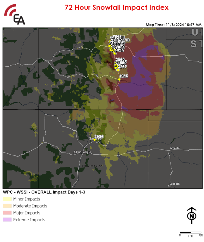
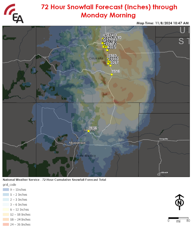
72 Hour Snowfall Impact Index:
12 – 18 Inches
NameCodeCityStateZipcode
Castle Rock FSU | 15801580Castle RockCO80108
Promenade at Castle Rock FSU | 40274027Castle RockCO80108
Parker FSU | 11111111ParkerCO80138
Southlands FSU | 15791579AuroraCO80016
6 – 12 Inches
NameCodeCityStateZipcode
S. Colorado and Yale FSU | 35163516DenverCO80222
Town Center at Aurora | 1111AuroraCO80012-2512
Cherry Creek FSU | 36433643DenverCO80246
Alameda Avenue FSU | 23472347AuroraCO80012
Denver West FSU | 31203120LakewoodCO80401
Colfax and Garfield FSU | 31373137DenverCO80206
Sloan's Lake FSU | 32403240EdgewaterCO80214
QCD-Aurora CO41AuroraCO80011
Gateway Park FSU | 32553255AuroraCO80011
I-70 and Youngfield St. FSU | 47464746Wheat RidgeCO80033
Quebec Street FSU | 34243424DenverCO80207
Keurig Dr Pepper Denver CO1506DenverCO80216-3625
Belmar FSU | 29522952LakewoodCO80226
Bimbo QSR Denver CO (Bimbo QSR Colorado,287DenverCO80216
FreshPoint - DenverDenverCO35231
52nd and Wadsworth FSU | 26362636ArvadaCO80002
Bimbo Bakery - Commerce City, COCommerce CityCO80022
Wadsworth Blvd at 80th Avenue FSU | 27212721ArvadaCO80003
MFS Denver CO (McLane Denver CO)121Commerce CityCO80022-8444
Denver International Airport | 8061080610DenverCO80249
104th and Federal FSU | 834834Federal HeightsCO80260
120th and Washington FSU | 12911291ThorntonCO80233
120th and Bradburn FSU | 40424042BroomfieldCO80020
Flatiron FSU | 12901290SuperiorCO80027
Orchard Park Place FSU | 36343634WestminsterCO80023
Mile Hi Bakery Denver CO (Mile Hi Bakery210DenverCO80216-3109
Gardens on Havana FSU | 19241924AuroraCO80012
Larkridge FSU | 20612061ThorntonCO80023
Broadway and Dartmouth FSU | 33363336EnglewoodCO80113
Pueblo FSU | 19161916PuebloCO81008
Fountain FSU | 32673267FountainCO80817
South Nevada Ave. FSU | 39953995Colorado SpringsCO80905
Citadel Crossing FSU | 44954495Colorado SpringsCO80909-8300
North Carefree FSU | 15501550Colorado SpringsCO80922
Garden of the Gods FSU | 23422342Colorado SpringsCO80907
Dublin Commons FSU | 39853985Colorado SpringsCO80923
North Academy Blvd. and I-25 FSU | 16901690Colorado SpringsCO80920
Northgate FSU | 35603560Colorado SpringsCO80921
University and Highlands Ranch Pkwy FSU | 689689Highlands RanchCO80126
Highlands Ranch Town Center FSU | 31833183Highlands RanchCO80129
Park Meadows Mall | 390390Lone TreeCO80124
C470 and Kipling FSU | 11101110LittletonCO80128
Park Meadows on County Line Rd FSU | 452452Lone TreeCO80124
Aspen Grove FSU | 36713671LittletonCO80120
Streets at Southglenn In-Line DT | 27592759CentennialCO80122
Greenwood Village FSU | 24792479Greenwood VillageCO80112
Chambers and Parker Road FSU | 13041304AuroraCO80015
Belleview Shores FSU | 26052605LittletonCO80123
River Point FSU | 22842284SheridanCO80110
Hampden and I-25 FSU | 29542954DenverCO80231
Brighton FSU | 19111911BrightonCO80601
2 – 3 Inches
NameCodeCityStateZipcode
Cerrillos Road FSU | 39363936Santa FeNM87505
Updates:

  • This will be the final update for this event barring an unexpected significant change in the forecast.


NOTE: The information presented in this report is the most up-to-date available at the time of release. Due to the uncertainty and chaotic nature of this situation, it is recommended that this report and content be used for preparedness and/or planning purposes only and not verbatim or a precise expectation.

Privileged and Confidential - The information contained in this mail transmission is privileged and confidential. If you are not the intended recipient, nor the employee or agent responsible for delivering it to the intended recipient, you are hereby notified that any dissemination or copying of this transmission (including any attachments) is strictly prohibited. If you have received this email in error, please notify the sender by email reply at alerts@earlyalert.com . Thank you.

Copyright Early Alert, Inc. All rights reserved. This article is protected by United States copyright and other intellectual property laws may not be reproduced, rewritten, distributed, re-disseminated, transmitted, displayed, published or broadcast, directly or indirectly, in any medium without the prior written permission of Early Alert Inc.


linkedin vimeo

earlyalert

877-932-5378

alerts@earlyalert.com

EarlyAlert.com
EarlyAlertCEMP.com


Addition support can be found at: 

TornadoAlert.com

TornadoDetector.us