EA Special Hazard Report | Front Range & Western Great Plains Strong Wind Gusts – Sunday Night through Monday Afternoon - 7:30 AM MST | Sunday December 29, 2024...

clientlogo sfa background

Front Range & Western Great Plains Strong Wind Gusts – Sunday Night through Monday Afternoon…

Issued: 7:30 MST | Sunday December 29, 2024

Strong Wind Gusts Overview:

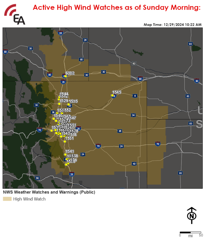
Area At Risk for Strong, Non-Thunderstorm Related Wind Gusts:

  • Southeastern Wyoming, including Cheyenne, eastern & northeastern Colorado, including the Denver and Colorado Springs Metros, far northwestern Kansas, and far southwestern Nebraska.

Timing:

  • Begins late this evening 
  • Ends Monday afternoon

Threat:

  • Sustained winds of 25-45 mph with gusts of 55-65 (locally 70) mph.
  • Blowing from the west towards the east late tonight then shifting to northwest to southeast by mid-morning Monday.

Additional Details:

  • A strong surface low will develop to the lee of the Wyoming Rockies this evening before quickly strengthening as the low pushes eastward late tonight, resulting in strong gusty winds across the Front Range & the Western Great Plains tonight through Monday afternoon.
Potential Disruptions & Recovery Weather:

  • Hazardous travel conditions for high-profile and lightweight vehicles with isolated brief road closures possible due to the potential for blow overs.
  • Due to downed trees & powerlines, isolated to scattered power outages possible.
  • Damage to roofs, metal awnings, fences, outbuildings, and unsecured structures can be expected.
  • Lightweight and/or unsecured outdoor objects including holiday decorations will likely become airborne due to strong winds.
  • Conditions will improve Monday evening as winds diminish. 
Locations at Risk for Wind Gusts of 55-65 (Locally 70) mph:
NameCodeCityStateRegioncode
ACADEMY BLVD1510COLORADO SPRINGSCOPAC MTN DESERT
ARVADA1502ARVADACOPAC MTN DESERT
AURORA, CO1501AURORACOPAC MTN DESERT
BEAR VALLEY1520DENVERCOPAC MTN DESERT
BOULDER1546BOULDERCOPAC MTN DESERT
BRIGHTON,CO1547BRIGHTONCOPAC MTN DESERT
BROOMFIELD1524BROOMFIELDCOPAC MTN DESERT
CASTLE ROCK1531CASTLE ROCKCOPAC MTN DESERT
CHEYENNE6002CHEYENNEWYPAC MTN DESERT
COLORADO SPRINGS1504COLORADO SPRINGSCOPAC MTN DESERT
DENVER SW1507DENVERCOPAC MTN DESERT
EVERGREEN1535EVERGREENCOPAC MTN DESERT
FIRESTONE1552FIRESTONECOPAC MTN DESERT
FORT COLLINS1512FORT COLLINSCOPAC MTN DESERT
GLENDALE,CO1526GLENDALECOPAC MTN DESERT
GOLDEN1522GOLDENCOPAC MTN DESERT
GREELEY1515GREELEYCOPAC MTN DESERT
GREENWOOD VILLAGE1509GREENWOOD VILLAGECOPAC MTN DESERT
HIGHLANDS RANCH1540HIGHLANDS RANCHCOPAC MTN DESERT
JEFFERSON COUNTY1549MORRISONCOPAC MTN DESERT
LAKEWOOD-NORTH1550LAKEWOODCOPAC MTN DESERT
LAKEWOOD, CO1514LAKEWOODCOPAC MTN DESERT
LITTLETON1519LITTLETONCOPAC MTN DESERT
LONGMONT1521LONGMONTCOPAC MTN DESERT
LOUISVILLE1506LOUISVILLECOPAC MTN DESERT
LOVELAND1529LOVELANDCOPAC MTN DESERT
MONUMENT1541MONUMENTCOPAC MTN DESERT
NE COLORADO SPRINGS1538COLORADO SPRINGSCOPAC MTN DESERT
NORTH AURORA1551AURORACOPAC MTN DESERT
NORTH FORT COLLINS1544FORT COLLINSCOPAC MTN DESERT
NORTH THORNTON1548THORNTONCOPAC MTN DESERT
PARK MEADOWS1508LONE TREECOPAC MTN DESERT
PARKER1516PARKERCOPAC MTN DESERT
PIONEER HILLS1523AURORACOPAC MTN DESERT
SADDLEROCK1528AURORACOPAC MTN DESERT
SANTA FE1505DENVERCOPAC MTN DESERT
STAPLETON1532DENVERCOPAC MTN DESERT
STERLING1545STERLINGCOPAC MTN DESERT
SW COLORADO SPRINGS1518COLORADO SPRINGSCOPAC MTN DESERT
THORNTON1503THORNTONCOPAC MTN DESERT
WESTMINSTER, CO1517WESTMINSTERCOPAC MTN DESERT
Updates:

  • We will continue to closely monitor this threat and will issue an update should significant changes in the forecast warrant.
For additional support or questions regarding this product, please reach out to your RDO.


NOTE: The information presented in this report is the most up-to-date available at the time of release. Due to the uncertainty and chaotic nature of this situation, it is recommended that this report and content be used for preparedness and/or planning purposes only and not verbatim or a precise expectation.

Privileged and Confidential - The information contained in this mail transmission is privileged and confidential. If you are not the intended recipient, nor the employee or agent responsible for delivering it to the intended recipient, you are hereby notified that any dissemination or copying of this transmission (including any attachments) is strictly prohibited. If you have received this email in error, please notify the sender by email reply at alerts@earlyalert.com . Thank you.

Copyright Early Alert, Inc. All rights reserved. This article is protected by United States copyright and other intellectual property laws may not be reproduced, rewritten, distributed, re-disseminated, transmitted, displayed, published or broadcast, directly or indirectly, in any medium without the prior written permission of Early Alert Inc.


linkedin vimeo

earlyalert

877-932-5378

alerts@earlyalert.com

EarlyAlert.com
EarlyAlertCEMP.com


Addition support can be found at: 

TornadoAlert.com

TornadoDetector.us