EA Special Hazard Report | Colorado Front Range Snow – Friday Evening through Saturday Evening – Update #1 – 7:30 AM MST | Friday January 17, 2025...

clientlogo sfa background

Colorado Front Range Snow – Friday Evening through Saturday Evening – Update #1

Issued: 7:30 AM MST | Friday, January 17, 2025

Purpose:

  • To address the increased snowfall totals in and around the Denver Metro through Saturday evening.

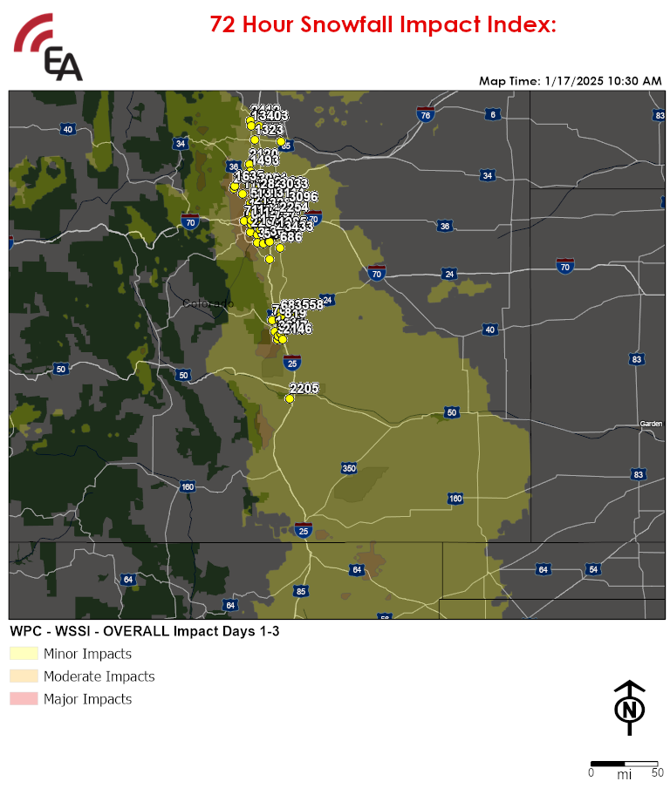
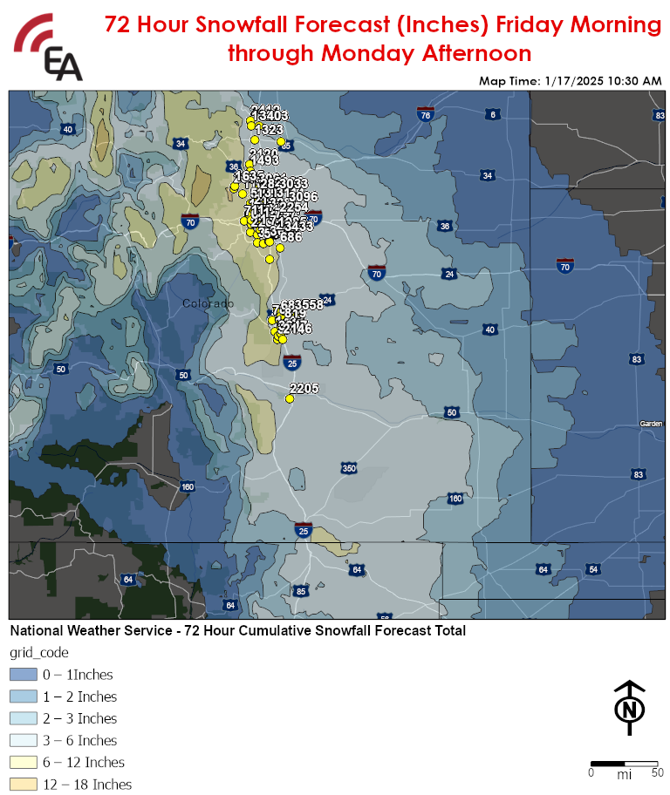
Winter Weather Overview:

Area At Risk for Impactful Winter Weather:

  • The Front Range of Colorado and far northeastern New Mexico, including the Denver, Boulder, Colorado Springs, and Pueblo Metros

Begins: From north to south late this afternoon through this evening

Ends: From north to south late Saturday morning through Saturday evening

Threat(s): Moderate Snow

  • 4-8 inches of snow in the Greater Denver Metro with 10-12 inches in the foothills west of town including Boulder.
  • 3-6 inches of snow from Colorado Springs south to far northwestern New Mexico along I-25.

Additional Details:

  • Lesser snow accumulations of up to 1-3 inches are expected in surrounding areas of the Front Range of Wyoming, eastern Colorado, northeastern New Mexico, and the far northwestern Texas Panhandle resulting in only minor impacts to travel.

Potential Disruptions & Recovery Weather:

  • Snowfall rates up to 1/2 inch per hour and visibility as low as 1/2 mile are possible at times.
  • Slippery to snow-covered roads will develop this evening and continue through Saturday evening, resulting in slowed to difficult travel for this evenings and Saturday’s commutes.
  • The commute on Saturday morning will be most impacted by snow-covered roads and reduced visibility.
  • Temperatures will remain below freezing through early next week and thus road clearing efforts will rely solely on mechanical snow clearing to improve road conditions.
  • An additional round of light snow is expected across the region Sunday evening through Monday morning, resulting in only light accumulations of up to 1-2 inches and nuisance impacts to travel.
  • Following this event, very cold temperatures with overnight lows ranging from -10 F to 5 F with wind chills as low as -10 to -25 F are expected Saturday evening through Tuesday morning. Outdoor exposure should be limited to prevent the development of hypothermia and frostbite.

6 – 12 Inches
NameCityStateZipcode
COLFAX and WADSWORTH | 1107LakewoodCO80214
KIPLING and 50TH | 1547Wheat RidgeCO80033
W 72nd Ave and Sheridan Blvd PX | 2118WestminsterCO80003
STANDLEY LAKE MKTPLC | 544WestminsterCO80020
104TH and CLAY | 1317DenverCO80234
COLORADO MILLS PX | 767GoldenCO80401
SUPERIOR MARKETPLACE | 1100SuperiorCO80027
University of Colorado PX | 2313BoulderCO80309
28TH and SPRUCE | 1635BoulderCO80301
144th and Washington PX | 2898ThorntonCO80023
LAKEWOOD CITY COMMON | 644LakewoodCO80226
Fort Carson PX | 3757Colorado SpringsCO80913
S Academy Blvd and Venetucci Blvd PX | 3647Colorado SpringsCO80906
SOUTHGATE and LYNN | 1437Colorado SpringsCO80906
Promenade Pkwy and Castlegate Dr PX | 3273Castle RockCO80108
VILLAGE CENTER PX | 545Highlands RanchCO80126
Lucent and Town Center Dr Highlands Ranch PX | 3429Highlands RanchCO80129
Park Meadows PX | 363LittletonCO80124
COUNTY LINE and WILLOW | 1515Lone TreeCO80124
SANTA FE DR and PRINCE | 674LittletonCO80120
Quincy Ave and Wadsworth Blvd PX | 2265LittletonCO80123
BROADWAY and CORNELL | 1360EnglewoodCO80113
3 – 6 Inches
NameCityStateZipcode
S Pueblo Blvd and Ivywood Ln PX | 2205PuebloCO81005
COLFAX and NOME | 1321AuroraCO80010
I-70 and Tower PX | 2254AuroraCO80011
QUEBEC and 36TH PX | 760DenverCO80207
56th and Central Park PX | 3287DenverCO80238
Denver International Airport II PX PX | 3096DenverCO80249
104th Ave and Chambers Rd PX | 3114Commerce CityCO80022
120TH and WASHINGTON | 711ThorntonCO80233
Prairie Center Pkwy and Eagle Blvd PX | 3033BrightonCO80601
Kuner and Bromley (Bromley Lane Shops) PX | 2086BrightonCO80601
Hwy 7 and Sheridan Pkwy PX | 3081BroomfieldCO80023
KEN PRATT and MARTIN | 1493LongmontCO80501
Hwy 66 and Main St PX | 2120LongmontCO80504
EISENHOWER and DENVER | 1323LovelandCO80537
CHERRYCREEK MALL | 1653DenverCO80206
ALAMEDA and SABLE PX | 797AuroraCO80012
S US Hwy 85-87 PX | 2146FountainCO80817
HANCOCK and ACADEMY | 1416Colorado SpringsCO80916
CITADEL MALL PX | 1127Colorado SpringsCO80909
POWERSand CONSTITUTION | 819Colorado SpringsCO80922
CENTENNIAL and GARDEN | 700Colorado SpringsCO80907
ACADEMY and UNION 2 | 879Colorado SpringsCO80918
WOODMEN and RANGEWOOD | 687Colorado SpringsCO80920
Meridian and E Woodmen PX | 3558FalconCO80831
Interquest Pkwy and Voyager Pkwy PX | 3387Colorado SpringsCO80921
PARKER and 20 MILE PX | 686ParkerCO80134
E Smoky Hill and S Gun Club Rd PX | 3433AuroraCO80016
Parker Rd and Chambers Rd PX | 2228AuroraCO80015
QUINCY and BUCKLEY | 1085AuroraCO80012
HAMPDEN and DAYTON | 721DenverCO80231
COLLEGE and HARMONY | 1322Fort CollinsCO80525
Colorado State University PX | 2412Fort CollinsCO80523
2 – 3 Inches
NameCityStateZipcode
HWY 34 and 47TH | 1276GreeleyCO80634
I-25 and Harmony PX | 3403TimnathCO80547
Updates:

  • We will continue to closely monitor this threat and will issue an update should significant changes in the forecast warrant.


NOTE: The information presented in this report is the most up-to-date available at the time of release. Due to the uncertainty and chaotic nature of this situation, it is recommended that this report and content be used for preparedness and/or planning purposes only and not verbatim or a precise expectation.

Privileged and Confidential - The information contained in this mail transmission is privileged and confidential. If you are not the intended recipient, nor the employee or agent responsible for delivering it to the intended recipient, you are hereby notified that any dissemination or copying of this transmission (including any attachments) is strictly prohibited. If you have received this email in error, please notify the sender by email reply at alerts@earlyalert.com . Thank you.

Copyright Early Alert, Inc. All rights reserved. This article is protected by United States copyright and other intellectual property laws may not be reproduced, rewritten, distributed, re-disseminated, transmitted, displayed, published or broadcast, directly or indirectly, in any medium without the prior written permission of Early Alert Inc.


linkedin vimeo

earlyalert

877-932-5378

alerts@earlyalert.com

EarlyAlert.com
EarlyAlertCEMP.com


Addition support can be found at: 

TornadoAlert.com

TornadoDetector.us